
Covering...
Early Novemeber 2007

Feedback
Just want to say 'Hi?'
Suggestions?
Comments?
 Our Photos Online
My avocation during our
travels is photography,
but Sandra is also taking
photos. Click the links
below to see our galleries
Sandra's Photos
Gordon's Photos
Sandra also posts her own news page
which can be read at this link...
Sandra's Nightly News
Items below are updated on average
once to three times a month...
 Didya Know?
The word millionaire was
first used by Benjamin
Disraeli in his 1826 novel
Vivian Grey.
If you stack one million
US $1 bills, it would be
110m (361 ft) high and
weight exactly 1 ton.
 A Spot 'O Humor
A thief stole a calendar
got twelve months.
A thief fell in wet cement,
broke his leg & became
a hardened criminal.
 Parting Thot
You cannot escape the
responsibility of
tomorrow by evading
it today.
– Abraham Lincoln
Cast of Characters
For those reading this page who might
not be familiar with the people in
my life, these are who I often refer to
without noting who they are
(in alphabetical order)...
Becky - Nick's wife
Betty - Sandra's older sister
Caden - Grandson
Carol - my younger sister
Danica - Margie's daughter
Eric - Son-in-law
Faith - Granddaughter
Garth - Betty's husband
Grace - Granddaughter
Ian - my son
John - Margie's husband
Lillian - Granddaughter
Luke - Grandson
Margie - Sandra's younger sister
Michelle - my daughter
Nick - Margie's son
Rick - Carol's husband
Sandra - my most wonderful wife
Tracy - Daughter-in-law
I Do The Lighthouse Trail
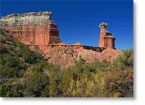 Thursday, 8 November 2007 - Today, I hiked the 3 mile (5 km) trail to the most popular natural attraction in the canyon, a rock formation commonly known as 'The Lighthouse', seen here on the right in the photo, but it's actual name is Lighthouse Peak. This formation is of the hoodoo variety, of which there are several around the park, this being by far the largest.
The views from the trail on the way to the formation are beautiful and worth the walk even if The Lighthouse wasn't there. You see canyon vistas that can't be seen from the road.
The trail, for the first 2.75 miles is relatively flat and an easy hike, rising 170 feet over that distance so you are ascending at an overall 1.1% grade, but you never know just how long a mile is until you hike it in the open country. They have markers every half mile and I was sure I'd walked a mile by the time I hit the half mile marker.
Everything you see regarding this hike tells you to take plenty of water and to not try it if you have any physical problems and not to try it at midday on a hot day and they are not understating things. It wasn't a particularly hot day today (77°F/25°C at noon) but by the time I reached the final part of the trail, a steep climb up that takes you closer to the formation itself, my heart was pounding and I was gasping for breath and had to sit for a few minutes until things calmed down before I could start the climb upward.
The problem is there is very little shade on the trail, so you are hiking in direct sunlight and you get hot quickly. I had started fairly early (9am) and it was still cool, so I had on a sweater as well as vest. The sweater didn't stay on for long and the vest was soon unzipped and by the time I got back to the truck, I'd drunk nearly all the liter of water I'd taken and my shirt was soaking wet with sweat.
There's a view point just before the halfway marker at 1.5 miles (2.5 km) and this is where one gets the first view of the formation. Before I reached it, I had met a couple about my age (61) who were walking back and they told me about the view point. I guess they'd seen enough at that point and were returning to the trailhead, but I wanted some closer shots of The Lighthouse, so I kept going. However if one simply wants to see it and has either binoculars or a camera with a long telephoto, the view from the view point is a good one.
The elevation at the trailhead is 2,830 feet and reaches 3,000 feet by the time one gets to the sharp climb upward, which looks to be another 100 feet or so before things level out again, still well below the shelf the formation sits on.
Under normal circumstances, I would have climbed around the base of the formation more than I did, but Sandra's lower back had gone out on her and I was anxious to get back in case she needed to go to a chiropractor.
For her account of the day, click here.
We Do The Caprock Escarpment
 Wednesday, 7 November 2007 - Well, at least a hundred miles of it. Yesterday, after getting directions for the most scenic route from our friendly park staff here in Palo Duro Canyon State Park, we set off to see other parts of the canyon outside the park and the canyon system to the south of it, all these canyons being along the Caprock Escarpment, a very scenic feature in an otherwise completely featureless landscape, or as the Spanish explorer Coronado described it, a sea of grass.
Ninety miles south southeast of here is the Caprock Canyons State Park and that was my actual destination, since I'd read reports that it was even prettier than Palo Duro Canyon, which I had to see to believe. We arrived in due course, after a haute cuisine lunch at the very down home Caprock Cafe in Quitaque (pronounced Kitty Kway), the town closest to the state park and which looked like it was on its way to becoming a ghost town, although they were doing road work along its main street and there were other signs of construction around town.
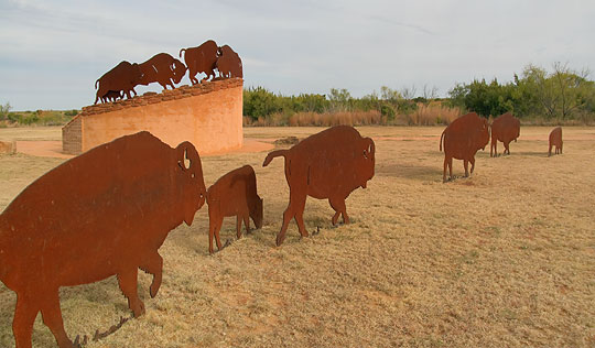
Anyway, we found our way to the state park, home of the official Texas State Bison Herd, and it was those bison I was also interested in getting photos of. However, we were quite disappointed to have found far more steel sculptures of bison (photo above) around the park than there were live bison, of which we saw only three bulls from the observation deck, one of which can be seen by clicking here. I've read the herd numbers 60 bison, but the other 57 of them were nowhere to be seen.
 So, for lack of bison to photograph, we drove into the park, and while it is indeed a very pretty place it was only a cliff-lined valley at the very end of road that had anywhere near the scenic impact of Palo Duro Canyon. A panorama photo of it that I shot can be seen by clicking here.
What had to be the highlight of the trip happened while we were leaving the park and that was seeing an armadillo, a creature Sandra has been wanting to see for years. It was most cooperative and we both got good photos of it, before it finally realized we were there (they have poor eyesight) and I was surprised at how agile and fast it was as it bounded away in great leaps for such a little creature. My photo of it can be seen by clicking here.
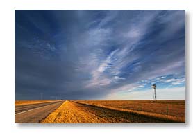
Otherwise, it was an interesting day, but full of disappointments and I found some of the rural High Plains scenes that we saw from the road (such as the photo above right) to be much more interesting than the Caprock Canyons.
Today was errand day in Amarillo (yawn). To read Sandra's account of it, click here.
For Sandra's account of our trip to Caprock Canyons, click here.
The Weekend in Palo Duro Canyon
 Monday, 5 November 2007 - First, let me say Happy 17th Anniversary to my most wonderful wife, who has given me the best 20 years of my life.
Second, let me say that we don't have cell phone coverage while we're here in Palo Duro Canyon. There is one short stretch along the park road a couple miles from here where we get a weak signal, but during our stay here, the best way to contact us is via email.
Now for the latest news.
Being retired and often losing track of not only what time it is, but even what day of the week it is (I haven't gotten to the point yet where I've lost track of the month though) it's often easy when we're staying in state or national parks to tell that it's the weekend by the hordes of people who suddenly show up.
Such was the case this weekend. Friday evening, before the weekend, when I was out in the park photographing, I almost had the place to myself. The previous two days though, it felt like I had people getting in my way every time I turned around, like the moron driving an SUV down the middle of the road at 15 mph with four kids on bicycles hanging onto the vehicle for a free ride. Not surprisingly, anyone so ignorant as to do that also didn't have the courtesy to pull over and let traffic pass him. As far as I know, it's illegal in most places for a cyclist to hang onto a moving vehicle due to the dangers involved, but one never knows what's legal or not in Texas, or if illegal, if it's enforced or not. Like a common practice here, at least along the Rio Grande, is to drive on the shoulder of two lane roads, assuming the shoulder is paved and wide enough, to let people pass you, whether there's oncoming traffic or not. Apparently this is illegal, but not enforced and has become common practice in that area. So who knows about towing kids on bicycles.
Anyway, I did manage to get out and about and shoot some photos, but not Saturday morning since it was cloudy. Because of that, we drove into the nearest town of any size, 10 miles (16 km) to the west and appropriately named Canyon, Texas, and ran the errands that needed to be run, like fueling up the truck and buying groceries. Canyon isn't that large (13,000 people or so), but it has a Super Wal-Mart, so Sandra is happy, and a Taco Bell, so I'm happy, and I expect we'll stay here as long as the weather stays warm enough.
And warm enough it certainly was yesterday, almost too warm at 87.8°F (31°C), but I'm not complaining. I tried to soak up as much of it as possible because a cold front is moving in today, so the upcoming days will be only mild and the nights near freezing – at least, outside the canyon. Down here, from what we've been told, it runs about 5°F (3°C) warmer than up on the rim, so we'll see.
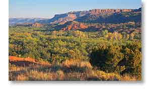
Otherwise, I've been out and about with my camera, taking photos around the canyon, like the one above, and yesterday Sandra and I hiked the Sunflower Trail and are planning to hike one of the other trails later today.
For Sandra's account of the weekend, click here and here.
Now in Palo Duro Canyon, Texas
 Friday, 2 November 2007 - We left El Reno, Oklahoma this morning at 9:18am after a pleasant overnight stay. The little RV park by the lake there would be ideal for overnighting if the dump station wasn't so difficult to find.
And as has too often happened, we had gone only a few miles when I saw some beautiful scenes I would have loved to photograph had I known they were there. These were of the Canadian River, but being on a freeway we couldn't stop, so hopefully I'll remember them the next we're in the area.
Anyway, today's drive (click here to see its map) to Palo Duro Canyon, Texas (one of our primary stops this winter) was 263 miles (423 km) which we made in 4.5 hours for an average speed of 58 mph (94 kph), getting only 10.5 mpg (16.9 kpg) mileage due to the climb in elevation from 1,400 feet to 3,600 feet and having some fairly brisk crosswinds. The day was beautiful and the drive uneventful until we got to the canyon itself with its mile long 10% grade that also has a couple of switchbacks. I knew this grade was there so it wasn't a surprise and was mentally prepared for it, but unfortunately we got stuck behind some moron who seemed scared out his pants by it, so he was just creeping down the grade at a crawl, forcing me to use the brakes more than I would have otherwise. However, I managed to keep them from overheating and we arrived at our campsite in due course and in fine shape.
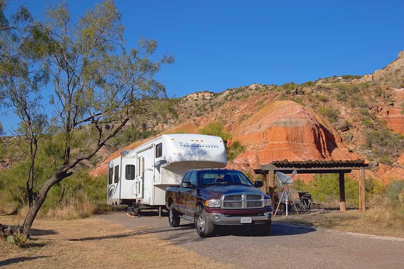
It's a back-in site (photo above), which we already knew as well since we had checked out the park when we discovered Palo Duro Canyon in April last year and fell in love with it, hoping to be able to return sometime when we could stay here for a while, and that sometime has proven to be now.
I managed to back-in without embarrassing myself, getting it on the first attempt and actually getting complimented by the park host (who had been watching), but getting the rig positioned exactly where we wanted it on the site took several efforts.
Setting up camp went smoothly, including accessing the satellites, although everything seemed to take longer than normal, maybe because I was quite tired and not moving too quickly. No doubt a physical letdown from actually having arrived at our first winter destination. Click here to see a map of the entire 1,545 mile (2,486 km) route from Ontario, which took 8 days, 5 of them actually being on the road, for an average of 309 miles (497 km) per day.
Despite being near exhaustion, I still went out to shoot some late afternoon, early evening photos. It is quite beautiful here and it's one of those places where there is a photo waiting to be taken wherever you look. Now to explore the place, which will no doubt take longer than the week we signed up to be here. One bonus of that was our Texas Parks Pass is still valid. We got it last winter in early November when were staying at the state parks around Rockport and it is good through the month of November this year.
For further information on Palo Duro Canyon than the site I've already linked to, click here, and here, and here, and here, and here.
For Sandra's account of the day, click here.
Now at El Reno, Oklahoma
 Thursday, 1 November 2007 - After taking a day off from travel yesterday to catch our breath, do laundry, and take a look at Joplin, a town I've often heard about but can't imagine why after seeing it, we were back on the road again today
The day again dawned bright and sunny and again with the temperature just a hair above freezing. I know this because there was frost on the windshield of the truck when I took it out to fuel up.
However, by the time we had packed and left the Joplin KOA RV park at 9:30am it had warmed up to 46°F (8°C) which is still cold enough.
The drive to our next stop, Lake El Reno RV Park on the outskirts of El Reno, Oklahoma, was uneventful except as we were leaving Oklahoma City and only a few miles from our destination, one last little road work zone at an overpass nearly caused us grief. The lanes were narrowed and shifted to go around the work area and the right lane, which we were in, was lined with concrete barriers (what else) and a truck decided it just had to pass us right as the lanes shifted and he didn't feel it necessary to stay completely out of my lane. Since I couldn't take my eyes off of him to watch the barrier, I kept as close to the truck as I could and prayed we cleared the barrier, which we did, but I don't know how. Our closest and scariest encounters on the road during the Odyssey have come from trucks. For supposedly being professional drivers I've found them to be unpredictable and when a truck is near me, I never take my eyes off of it until we're clear.
Then there are the bozo car drivers who don't know how to properly merge into traffic when entering a freeway, but that's another subject to rant about another day. By and large, we've otherwise encountered surprisingly few bad drivers.
 Anyway, today's 240 mile (386 km) drive (click here to see it) took just over 4 hours for an average of 56 mph (91 kph) and 13.2 mpg (21.2 kpg), which is about what we normally expect to get. We arrived at El Reno a little before 2pm and easily found the Lake El Reno RV Park (despite conflicting information in the directions we had found on the internet) and were quickly setup for an overnight stay.
This park is interesting in that it is quite small, having only about 12 pull through sites and about half that many back-ins, but was still nearly empty when we arrived, despite only costing $10/night. I suspect the lack of activity here is due to the park being almost unpublicized. There's scarcely any information about it anywhere. But that was good for us since we had no trouble finding a spot that suited us.
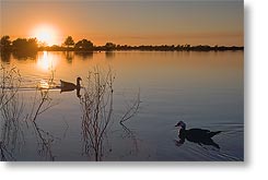
The surroundings are fairly scenic, as much as they can be in an area that's flat as a pancake and the lake looking to be man-made (photo above left). The only real drawback to the place is there is no sewer hookup and the dump station is almost impossible to find, being located out of the immediate area entirely, over by the entrance to the local hospital. Go figure that one (probably the furthest the town's sewers run), but at $10/night who's to complain too loudly.
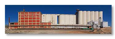
After camp was setup, we still had enough energy to drive into town and look around a bit. El Reno, which I had never heard of before, looks to be a fairly typical town for the region, but the lake does set it apart and it does have quite a number of grain elevators, structures I find interesting (photo above right is of the largest one here).
Tomorrow we head for our first serious photography site of this winter's tour, Palo Duro Canyon near Amarillo, Texas. The canyon is another fairly unpublicized place, but we were there briefly two years ago when we passed through Amarillo on our way back north, but didn't have time to linger, so we've been looking forward to returning there ever since. The drive from here to there is about the same distance as today's drive was, but I don't expect to get nearly the same mileage because we will change elevation from 1,400 feet to 3,600 feet, so quite a climb.
For Sandra's account of the day, click here.
__________________________
For Older News
To read details of our previous stops and camps, visit the News Archives.
Updated
Copyright © 2007 by Gordon L Wolford .
All rights reserved.