
Covering...
Early January 2009
Location during that period...
Port Lavaca, Texas USA
A Day's Tour Around Aransas Bay
 Wednesday, 14 January, 2009 - Yesterday, we made the long awaited drive down to Aransas Bay to see Rockport and to continue on to Mustang Island, in other words, to visit our usual haunts from our previous stays on the Coastal Bend of Texas. Click here to see a map of the 100 mile (160 km) tour.
The most interesting thing we saw on the way to Rockport, a drive that's normally pretty boring until you get to Copano Bay, was a huge field full of sandhill cranes. There had to be thousands of them, but they weren't that easy to see as they rather blended into the color and texture of the field, but still quite a sight. Jim and Ellie had seen them the day before and told us about them, so we were on the lookout for them but not really expecting them to still be there, so it was quite surprising when we saw they were. Must have been something very appetizing to cranes in that field.
Our first stop as we neared Rockport was Goose Island State Park, where we made reservations to stay two weeks when we leave Port Lavaca near the end of this month. Goose Island is my favorite place to stay in the Rockport area, but not particularly inexpensive, so we also looked at a couple of other RV parks during the drive and were disappointed to see how tight the campsites were in all of them we saw. We've gotten used to being in roomy sites and I'm not sure we want to spend much time in an RV park where they pack you in like sardines...if we have a choice. It always gets crowded down here after Christmas and one's options can get very limited. Even the Marina Beach RV Park in Port Aransas where we stayed for a month two years ago looked very cramped and it didn't strike me that way back then, but they've rearranged things and if I'm not mistaken added sites, making it now feel as crowded as all the others.
Anyway, after making reservations at Goose Island, we drove around it for a while and I tried to walk out on its pier, but the wind was quite strong and the day not what you'd call overly warm to begin with, so after taking a few shots of a group of willets, we left Goose Island and crossed the Copano Bay Bridge and stopped in Rockport for lunch and to look around town to see what was new and discovered they'd done a lot of cleaning up over the last two years and were still in the process. The harbor looks almost civilized now.
 From there, we continued south to the town of Aransas Pass, which we drove through without stopping, and in due course arrived at the ferry that takes you across the Corpus Christi Ship Channel in Redfish Bay to Port Aransas on Mustang Island.
Nothing had changed about the ferry, which was good because not only is it free but it's one of the best operated ferry systems I've ever seen.
On arrival in Port Aransas we saw little had changed there too, but south of town the developers had been busy during our two year absence, putting up a lot of housing and resorts and it looks like Mustang Island will soon be no different from the overcrowded barrier islands around Florida. Such a pity, but at least the Mustang Island State Park will preserve some of its natural state, that is until the next big hurricane blows through and returns the whole island back to nature. It absolutely mystifies me why barrier islands are allowed to be developed. Gulf coast barrier islands have got to be one of the riskiest places to build on.
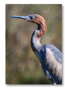
Anyway, no visit to Port Aransas would be complete without a stop at the Leonabelle Turnbull Birding Center, one of the few places of this kind where we have always found a multitude of interesting birds to view and photograph and this time was no different, which I was happy to see because I was keen to try out the new lens there. The reddish egret pictured above on the right was just one of several extremely cooperative birds that allowed us to get reasonably close. It was perched on the railing of the boardwalk to bid us a fond farewell as we were leaving.
From there we drove down to Mustang Island State Park, just to see it again and Sandra really likes walking on the beach there, so we did the beach thing for a while and then headed back for Port Aransas. We probably need to spend some time in Corpus Christi, which is nearby, so we might move to this state park for a couple of weeks too, but where we go after leaving Goose Island is still undecided.
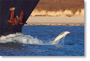
Back in Port Aransas, we toured around to some of our other favorite places, including one of the public fishing piers where I got the photo above on the left of the dolphin racing a ship. This is so fascinating to watch and I almost missed it, but Sandra saw it and called my attention to it.
Then it was time to boogie for home as it was getting late in the day and I was hoping to get back before dark, but we did take enough time to take the scenic route (the beach road) through Rockport and Fulton instead of the highway and got home as twilight was fading. It was a good day.
Click here for Sandra's account of the day and a lot more photos.
New Neighbors
 Friday, 9 January, 2009 - Yesterday, Jim and Ellie arrived for a stay here beside Powderhorn Lake. They are in the site next to us, so I hope they behave themselves. Sandra and Ellie hang out in the same online RV chatroom and we all met in person in mid-December a year ago, during our stay near Tucson, Arizona.
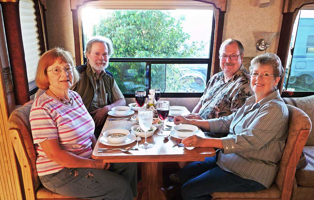
So, we had them over for a dinner last night (photo on the right) of 'white chili', a new recipe for Sandra, so we were guinea pigs for her. I thought it came out quite well, but unfortunately the chili didn't end up agreeing with Sandra's acid reflux condition.
Then this morning, we gave Jim and Ellie the 5 cent tour of the immediate area to get them oriented quickly and near the end of the tour some of the birds (3 sandhill cranes and a small flock of roseate spoonbills) even put on a show for them.
Other than the arrival of the new neighbors, we haven't done much of note since the last report.
Monday, we made a trip into town for Sandra to see a dentist to get her teeth cleaned and on the way home we witnessed a cloud of snow geese flying out.
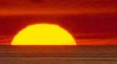
Thursday morning before Jim and Ellie arrived, was the only other excitement we had when we had a sunrise worth photographing and I then went into town to get propane. Otherwise, all I've done is go out each day to get used to shooting with the new lens.
For Sandra's account of the last few days and for a lot more photos, click here.
A Cruise On Powderhorn Lake
 Sunday, 4 January, 2009 - For several weeks the owner of the RV park, Delmer, has been wanting to take me on a tour of Powderhorn Lake in his boat, but the few times the weather was suitable for photography, our schedules conflicted. We've had some generally good weather, but a lot of overcast and wind for the most part, and then I wanted to wait for the new lens to arrive, so we had a lot of postponements, but this afternoon it all came together and Delmer and I finally got out on the lake.
However, as things have gone with this endeavor, we had no sooner gotten a good start than a norther blew in, literally within a matter of a few minutes, and we had to race back to the marina. In a half hour, we went from sunny and warm to overcast with the temperature dropping from 75°F (24°C) to 55°F (13°C).
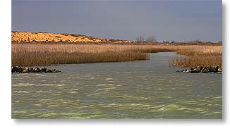
But the short time we were on the water wasn't wasted. Just west of the RV park is the Myrtle Foester-Whitmire Unit, one of five units of the Aransas National Wildlife Refuge, and Delmer had told me there were often a lot of birds to be seen near the water there. We didn't see many birds this time, but at least I got to see what the area looks like (photo above). It is otherwise not accessible to the public, probably a good thing for the birds, but not so good for photographers.
We made it back to the marina with time to spare. Click here to see what the norther looked like from the RV park's pier as the front of the weather system had moved over the lake. I've seen several of these northers now and they are more blow than show, dark impressive looking clouds that don't develop into anything as nasty as they look. Just turn the weather colder.
For Sandra's account of the day and improved photos due to the increased capabilities of her new camera, click here.
Goliad - A Great Start To 2009
 Thursday, 1 January, 2009 - We decided around noon to go see some sights as a way to welcome in the new year.
A week or two ago, we had set out to see Goliad, a very historic town that more than one person has highly recommended we see while we're in this area, but although the sky was clear when we left the RV, it clouded up before we had even reached Port Lavaca, so we didn't go.
Today, being another pretty nice day, we again headed for Goliad and hoped history wouldn't repeat itself. However that was not meant to be as we once more encountered a bank of overcast in almost the same place as before, but this time we resigned ourselves to having less than cooperative weather and pushed on anyway.
Goliad is 67 miles (108 km) from here, but since the speed limit on the two lane roads around here is 70 mph (112 kph) it only took about an hour to get there. All I could remember that I had been told about the place was that an old Spanish mission was there, along with some other old historic things.
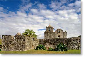
What we first encountered just south of town was the Presidio La Bahia (presidio being Spanish for fortress), so this was a Spanish fort back when Spain ruled Texas. Unfortunately, being the New Year's Day holiday, access to the inside of the fort was closed, but we took plenty of photos around the outside (photo above) and as can also be seen in that photo, we got a break in the clouds.
However, although the presidio has its own church, (Our Lady of Loreto Chapel) which is one of the oldest churches in Texas, it wasn't the mission I wanted to see, but we found that, (Mission Espiritu Santo), just a short distance up the road as part of the Goliad State Park & Mission Espíritu Santo State Historical Site.
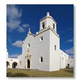 The state park proved to be a worthwhile stop, not only for seeing the mission (photo on the right), but for buying a Texas State Parks Pass, which we'll be needing after we leave Port Lavaca, and for what we learned there, which was they have a very nice campground with pull-thru sites large enough to take a rig the size of ours and even have 50 amp service, plus we learned there's more we want to see in the area. So we're planning on moving the rig there for a while later this winter.
After finally seeing the mission inside and out (unlike the presidio, the mission was open), we discovered the downtown of Goliad is quite nice and interesting. It rather reminded me of Canton, Mississippi, but even better, so spending some time photographing the town is now on my list of things to do when we relocate there.
From Goliad, we then drove 30 miles (50 km) north to the town of Cuero, which is another place that was recommended we see. Apparently, when Indianola (where we are currently located within sight of) was destroyed in the late 1800s by two hurricanes, many of the survivors relocated to Cuero. It was an interesting place too, but not nearly to the same degree as Goliad.
By then, it was getting late in the afternoon, so we headed for home, with plans to stop on the way in Victoria for dinner out to celebrate the new year and take some night photos in the picturesque town plaza there, which I heard was lit up at night. We did enjoy a dinner out, but it was at a Taco Bell, so while the food was tasty, the ambience lacked the charm we had hoped to dine in, but since it was about the only restaurant of any kind we saw that was open, our choices were severely limited. By the time we finished eating, it was still too light out for night photography and since we were both too tired to sit around and wait for twilight, we just headed for home. There will be other nights in Victoria, I expect.
In total the distance traveled for this little outing was 165 miles (265 km) and we had a great time.
For Sandra's account of the day and more photos she took with her new camera, click here.
__________________________
For Older News
To read details of our previous stops and camps, visit the News Archives.
Updated
Copyright © 2009 by Gordon L Wolford .
All rights reserved.
Sandra also posts her own 'blog' (news
page), which can be read at this link...
Sandra's Nightly News
My Photos Online

During our travels, my
avocation is photography.
Click the links below
to view my photos or to
ask about purchasing
any of them.
Gordon's Photos
Purchase Inquiry

Feedback
Just want to say 'Hi?'
Suggestions?
Comments?
Items below are updated on average
once to three times a month...
 Didya Know?
Railroad's “golden age”
began in 1865. For nearly
half a century, no other
mode of transportation
challenged railroads.
During these years, the rail
network grew from 35,000
miles to a peak in 1916 of
254,000 miles.
 A Spot O' Humor
The US has developed a
new weapon that destroys
people but leaves
buildings standing. It's
called the stock market.
(Jay Leno)
 Parting Thot
What things cost under
earlier conditions is
history; what the supply
and demand are today
is economics.
– Thomas Sowell
Cast of Characters
For those reading this page who might
not be familiar with the people in
my life, these are who I often refer to
without noting who they are
(in alphabetical order)...
Becky - Nick's wife
Betty - Sandra's older sister
Caden - Grandson
Carol - my younger sister
Danica - Margie's daughter
Eric - Son-in-law
Faith - Granddaughter
Garth - Betty's husband
Grace - Granddaughter
Ian - my son
Iris - Granddaughter
John - Margie's husband
Lillian - Granddaughter
Luke - Grandson
Margie - Sandra's younger sister
Michelle - my daughter
Miss Pinky - our GPS navigator
Nick - Margie's son
Rick - Carol's husband
Sandra - my most wonderful wife*
Tracy - Daughter-in-law
*(a.k.a. 'Grammy' to some)